IMAGES TAKEN NEAR TO
Burners Lane, MILTON KEYNES, MK11 3HD
Introduction
This page details the photographs taken nearby to Burners Lane, MK11 3HD by members of the Geograph project.
The Geograph project started in 2005 with the aim of publishing, organising and preserving representative images for every square kilometre of Great Britain, Ireland and the Isle of Man.

There are currently over 7.5m images from over14,400 individuals and you can help contribute to the project by visiting https://www.geograph.org.uk
Image Map
Images are licensed for reuse under creativecommons.org/licenses/by-sa/2.0
Notes
- Clicking on the map will re-center to the selected point.
- The higher the marker number, the further away the image location is from the centre of the postcode.
Image Listing (10 Images Found)
Images are licensed for reuse under creativecommons.org/licenses/by-sa/2.0
Image
Details
Distance
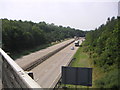
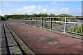
3
The A5 at the Millers Way flyover, Milton Keynes
Image: © David Howard
Taken: 2 Aug 2022
0.10 miles
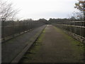
4
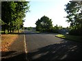
Burners Lane South
Situated in Kiln Farm, an industrial estate area of Milton Keynes. At the end of the road turning right brings you to the cul-de-sac of Potters Lane.
Image: © DS Pugh
Taken: 8 Aug 2007
0.11 miles
5
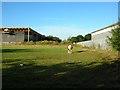
Horse - Kiln Farm
A horse stands tethered in Kiln Farm industrial estate, Milton Keynes.
Image: © DS Pugh
Taken: 8 Aug 2007
0.17 miles
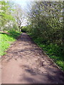
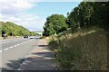
7
North Bucks Way
North Bucks Way heading over A5 towards Kiln Farm
Image: © Shaun Ferguson
Taken: 20 Nov 2015
0.19 miles

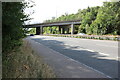
10

Milton Keynes : The A5
The A5 heading through Milton Keynes.
Image: © Lewis Clarke
Taken: 18 Mar 2019
0.24 miles