IMAGES TAKEN NEAR TO
Pitfield, MILTON KEYNES, MK11 3DR
Introduction
This page details the photographs taken nearby to Pitfield, MK11 3DR by members of the Geograph project.
The Geograph project started in 2005 with the aim of publishing, organising and preserving representative images for every square kilometre of Great Britain, Ireland and the Isle of Man.

There are currently over 7.5m images from over14,400 individuals and you can help contribute to the project by visiting https://www.geograph.org.uk
Image Map
Images are licensed for reuse under creativecommons.org/licenses/by-sa/2.0
Notes
- Clicking on the map will re-center to the selected point.
- The higher the marker number, the further away the image location is from the centre of the postcode.
Image Listing (11 Images Found)
Images are licensed for reuse under creativecommons.org/licenses/by-sa/2.0
Image
Details
Distance
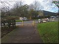
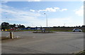
1
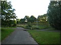
Junction of paths near Monk's Way
Several paths crossing close to Monk's Way in Kiln Farm. Round the corner is the golf course.
Image: © DS Pugh
Taken: 8 Aug 2007
0.07 miles
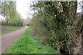
4
North Bucks Way
North Bucks Way crossing over Pitfield
Image: © Shaun Ferguson
Taken: 20 Nov 2015
0.20 miles
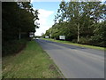
5
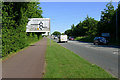
Watling Street, Milton Keynes
Looking south-east towards the roundabout at Calverton Lane.
Image: © Cameraman
Taken: 3 Jun 2011
0.20 miles
6
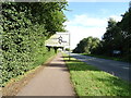
Cycle path into Milton Keynes
Beside Watling Street.
Two of the 124 roundabouts of Milton Keynes ahead.
Image: © JThomas
Taken: 17 Aug 2019
0.20 miles
7
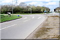
Calverton Lane junction with Watling Street
With travellers horse
Image: © Philip Jeffrey
Taken: 2 Apr 2012
0.21 miles
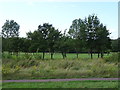
9
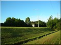
Embankment along Monk's Way
Looking towards Monk's Way which is hidden from the path along the golf course by the embankment.
Image: © DS Pugh
Taken: 8 Aug 2007
0.21 miles