IMAGES TAKEN NEAR TO
Honeyball Walk, SITTINGBOURNE, ME9 9TL
Introduction
This page details the photographs taken nearby to Honeyball Walk, ME9 9TL by members of the Geograph project.
The Geograph project started in 2005 with the aim of publishing, organising and preserving representative images for every square kilometre of Great Britain, Ireland and the Isle of Man.

There are currently over 7.5m images from over14,400 individuals and you can help contribute to the project by visiting https://www.geograph.org.uk
Image Map
Images are licensed for reuse under creativecommons.org/licenses/by-sa/2.0
Notes
- Clicking on the map will re-center to the selected point.
- The higher the marker number, the further away the image location is from the centre of the postcode.
Image Listing (77 Images Found)
Images are licensed for reuse under creativecommons.org/licenses/by-sa/2.0
Image
Details
Distance
7
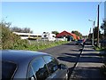
Rural enterprise by the railway
In the narrow strip of land between Lower Road and the railway on the western edge of Teynham, old buildings are being used by a car mechanic.
Image: © Penny Mayes
Taken: 3 Nov 2006
0.09 miles