IMAGES TAKEN NEAR TO
Station Road, SITTINGBOURNE, ME9 9TB
Introduction
This page details the photographs taken nearby to Station Road, ME9 9TB by members of the Geograph project.
The Geograph project started in 2005 with the aim of publishing, organising and preserving representative images for every square kilometre of Great Britain, Ireland and the Isle of Man.

There are currently over 7.5m images from over14,400 individuals and you can help contribute to the project by visiting https://www.geograph.org.uk
Image Map
Images are licensed for reuse under creativecommons.org/licenses/by-sa/2.0
Notes
- Clicking on the map will re-center to the selected point.
- The higher the marker number, the further away the image location is from the centre of the postcode.
Image Listing (83 Images Found)
Images are licensed for reuse under creativecommons.org/licenses/by-sa/2.0
Image
Details
Distance
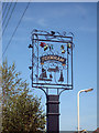
1
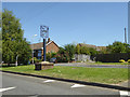
Teynham village sign
On Station Road.
Image: © Robin Webster
Taken: 14 Jun 2017
0.02 miles
4
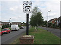
Teynham Village Sign
On a long green between Station Road (on left) and Bradfield Avenue (on right).
Has an unusual brick plinth for the post of the sign. The road leads down to the railway station from the A2 London Road.
Image: © David Anstiss
Taken: 13 Aug 2009
0.03 miles
5
Teynham Village Sign
On Station Road.
Image: © Oast House Archive
Taken: 19 Aug 2009
0.03 miles
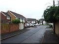
6
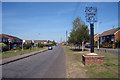
Station Road, Teynham
Teynham village sign to right Image
Image: © Oast House Archive
Taken: 19 Aug 2009
0.03 miles