IMAGES TAKEN NEAR TO
Dully Road, SITTINGBOURNE, ME9 9PD
Introduction
This page details the photographs taken nearby to Dully Road, ME9 9PD by members of the Geograph project.
The Geograph project started in 2005 with the aim of publishing, organising and preserving representative images for every square kilometre of Great Britain, Ireland and the Isle of Man.

There are currently over 7.5m images from over14,400 individuals and you can help contribute to the project by visiting https://www.geograph.org.uk
Image Map (Loading...)


Getting Data...Please wait
Leaflet Map data © OpenStreetMap
Images are licensed for reuse under creativecommons.org/licenses/by-sa/2.0
Notes
- Clicking on the map will re-center to the selected point.
- The higher the marker number, the further away the image location is from the centre of the postcode.
Image Listing (5 Images Found)
Images are licensed for reuse under creativecommons.org/licenses/by-sa/2.0
Image
Details
Distance
3
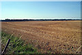
Harvested Crop field
Off Dully Road
Image: © Oast House Archive
Taken: 19 Aug 2009
0.18 miles
4
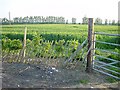
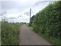
New Beech Hedge
Around this field of wheat on Dully Road.
Image: © Penny Mayes
Taken: 27 May 2005
0.19 miles
5
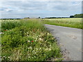
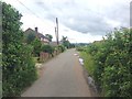
Dully Road
This is seen from the junction with Kingsdown Road. The houses in the distance are at Newbury.
Image: © Marathon
Taken: 21 Jun 2019
0.20 miles