IMAGES TAKEN NEAR TO
Lower Norton Lane, SITTINGBOURNE, ME9 9LB
Introduction
This page details the photographs taken nearby to Lower Norton Lane, ME9 9LB by members of the Geograph project.
The Geograph project started in 2005 with the aim of publishing, organising and preserving representative images for every square kilometre of Great Britain, Ireland and the Isle of Man.

There are currently over 7.5m images from over14,400 individuals and you can help contribute to the project by visiting https://www.geograph.org.uk
Image Map
Images are licensed for reuse under creativecommons.org/licenses/by-sa/2.0
Notes
- Clicking on the map will re-center to the selected point.
- The higher the marker number, the further away the image location is from the centre of the postcode.
Image Listing (18 Images Found)
Images are licensed for reuse under creativecommons.org/licenses/by-sa/2.0
Image
Details
Distance

4
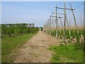
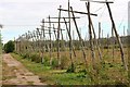
Apples and hops near Norton Ash
Apple orchards to the left and hops to the right with a stack of bushel boxes (for the apple crop) at the far end of the track. Just north of the A2 in the NW corner of the square.
Image: © Penny Mayes
Taken: 12 May 2006
0.18 miles
6
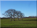
Five trees in a field by Lower Norton Lane
Near the lane's junction with Lower Road, Norton.
Image: © pam fray
Taken: 9 Jan 2011
0.20 miles

8
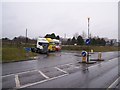
Former Garden Centre Entrance
It started out life in the '70s as Norton Ash Garden Centre, a small family owned business with just the one big greenhouse, and a bit of outdoor space. It expanded through the '80s and '90s with numerous extensions, a restaurant and pet centre were added, and a lot more outdoor space was utilised. It was brought out by Country Gardens in the 1990s, it also had a small miniature railway, running on weekends for children, by volunteers. Very popular and successful. Then became Wyvale (who created the new road entrance in photo), but did not do anything about the ageing greenhouse and related buildings, ran it for the last few years of its life until it closed in January 2007. Now empty and desolate, and the entrance has become a lorry park for over-night stays.
Image: © David Anstiss
Taken: 13 Dec 2008
0.20 miles