IMAGES TAKEN NEAR TO
Harrys Road, SITTINGBOURNE, ME9 9DT
Introduction
This page details the photographs taken nearby to Harrys Road, ME9 9DT by members of the Geograph project.
The Geograph project started in 2005 with the aim of publishing, organising and preserving representative images for every square kilometre of Great Britain, Ireland and the Isle of Man.

There are currently over 7.5m images from over14,400 individuals and you can help contribute to the project by visiting https://www.geograph.org.uk
Image Map
Images are licensed for reuse under creativecommons.org/licenses/by-sa/2.0
Notes
- Clicking on the map will re-center to the selected point.
- The higher the marker number, the further away the image location is from the centre of the postcode.
Image Listing (76 Images Found)
Images are licensed for reuse under creativecommons.org/licenses/by-sa/2.0
Image
Details
Distance
1
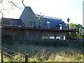
Rural enterprise by the railway
In the narrow strip of land between Lower Road and the railway on the western edge of Teynham, old buildings are being used by a car mechanic.
Image: © Penny Mayes
Taken: 3 Nov 2006
0.01 miles
7
Teynham Oast
Standing immediately behind the railway station this old oast house and barn seems to be undergoing some refurbishment.
Image: © Penny Mayes
Taken: 3 Nov 2006
0.07 miles
10
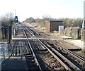
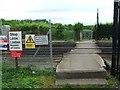
View from the platform at Teynham station
The section of the East Kent Railway between Chatham and Faversham opened on 25th January 1858, and Teynham station opened with the line. The original two-storey brick built station was demolished in the 1970s and replaced by the prefabricated buildings popular at the time.
This is the view from the end of the platform looking in the direction of Sittingbourne. The foot crossing carries the footpath between Teynham and Conyer.
Image: © Marathon
Taken: 5 Mar 2013
0.07 miles