IMAGES TAKEN NEAR TO
Thornhill Gardens, SITTINGBOURNE, ME9 9BF
Introduction
This page details the photographs taken nearby to Thornhill Gardens, ME9 9BF by members of the Geograph project.
The Geograph project started in 2005 with the aim of publishing, organising and preserving representative images for every square kilometre of Great Britain, Ireland and the Isle of Man.

There are currently over 7.5m images from over14,400 individuals and you can help contribute to the project by visiting https://www.geograph.org.uk
Image Map
Images are licensed for reuse under creativecommons.org/licenses/by-sa/2.0
Notes
- Clicking on the map will re-center to the selected point.
- The higher the marker number, the further away the image location is from the centre of the postcode.
Image Listing (11 Images Found)
Images are licensed for reuse under creativecommons.org/licenses/by-sa/2.0
Image
Details
Distance
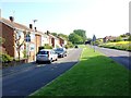
9
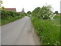
Panteny Lane, Bapchild
The built-up area of Bapchild is to the left while open fields are to the right, although new housing is being built closer to the A2.
Image: © Marathon
Taken: 29 May 2016
0.21 miles
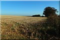
10
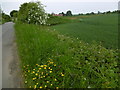
Fields next to Panteny Lane, Bapchild
The built-up area of Bapchild is to the left while open fields are to the right, although new housing is being built closer to the A2. This can be seen in the distance.
Image: © Marathon
Taken: 29 May 2016
0.22 miles