IMAGES TAKEN NEAR TO
Tonge Corner, SITTINGBOURNE, ME9 9AX
Introduction
This page details the photographs taken nearby to Tonge Corner, ME9 9AX by members of the Geograph project.
The Geograph project started in 2005 with the aim of publishing, organising and preserving representative images for every square kilometre of Great Britain, Ireland and the Isle of Man.

There are currently over 7.5m images from over14,400 individuals and you can help contribute to the project by visiting https://www.geograph.org.uk
Image Map
Images are licensed for reuse under creativecommons.org/licenses/by-sa/2.0
Notes
- Clicking on the map will re-center to the selected point.
- The higher the marker number, the further away the image location is from the centre of the postcode.
Image Listing (5 Images Found)
Images are licensed for reuse under creativecommons.org/licenses/by-sa/2.0
Image
Details
Distance
1
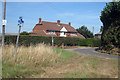
House at Tong Corner Farm
From Church Road
Image: © Oast House Archive
Taken: 19 Aug 2009
0.05 miles
3
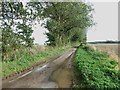
Lane between Little Murston and Tonge Corner
Image: © Chris Whippet
Taken: 20 Oct 2013
0.19 miles
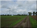
5
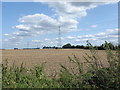
Looking towards Tonge Corner Farm
This view is from just beyond the end of the metalled road as it turns towards Little Murston and The Swale at the old Elmley Ferry. The view looks back towards Tonge Corner Farm.
Image: © Marathon
Taken: 20 Aug 2019
0.25 miles