IMAGES TAKEN NEAR TO
Ferry Road, SITTINGBOURNE, ME9 8RE
Introduction
This page details the photographs taken nearby to Ferry Road, ME9 8RE by members of the Geograph project.
The Geograph project started in 2005 with the aim of publishing, organising and preserving representative images for every square kilometre of Great Britain, Ireland and the Isle of Man.

There are currently over 7.5m images from over14,400 individuals and you can help contribute to the project by visiting https://www.geograph.org.uk
Image Map
Images are licensed for reuse under creativecommons.org/licenses/by-sa/2.0
Notes
- Clicking on the map will re-center to the selected point.
- The higher the marker number, the further away the image location is from the centre of the postcode.
Image Listing (31 Images Found)
Images are licensed for reuse under creativecommons.org/licenses/by-sa/2.0
Image
Details
Distance
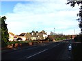
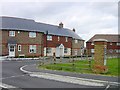
3
New Houses, Monins Road, Iwade, Kent
Image: © Oast House Archive
Taken: 21 Sep 2008
0.05 miles
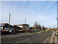
5
New Housing
Curiously curved new housing at Iwade. This road isn't yet on the map.
Image: © Penny Mayes
Taken: 21 May 2005
0.07 miles
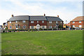
7
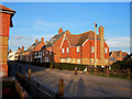
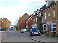
Church Mews, Iwade
This road used to be the main route to the Isle of Sheppey, but after the building of a bypass, Iwade has returned to being a sleepy village... actually NOT - much new housing has been built including this "villagy looking" row.
Image: © Richard Dorrell
Taken: 27 Jan 2008
0.09 miles
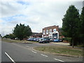
8
Health Centre
Newly built to service the needs of this rapidly expanding community.
Image: © Penny Mayes
Taken: 21 May 2005
0.09 miles
9
Cormorant Road, Iwade
One of the newer parts of the greatly expanded village.
Image: © Robin Webster
Taken: 21 Mar 2017
0.13 miles
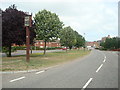
10
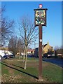
Iwade Village Sign
On green at junction of Sheppey Way and Sheerstone Road. Sheppey Way seen in background towards Village centre. On signpost is a (shiny) metal plate with engraving, which reads 'Ted Cornford donated this village sign in 2005, to the memory of his wife Jay Cornford 1924-2005'.
Image: © David Anstiss
Taken: 3 Jan 2006
0.13 miles