IMAGES TAKEN NEAR TO
Sheppey Way, SITTINGBOURNE, ME9 8QN
Introduction
This page details the photographs taken nearby to Sheppey Way, ME9 8QN by members of the Geograph project.
The Geograph project started in 2005 with the aim of publishing, organising and preserving representative images for every square kilometre of Great Britain, Ireland and the Isle of Man.

There are currently over 7.5m images from over14,400 individuals and you can help contribute to the project by visiting https://www.geograph.org.uk
Image Map
Images are licensed for reuse under creativecommons.org/licenses/by-sa/2.0
Notes
- Clicking on the map will re-center to the selected point.
- The higher the marker number, the further away the image location is from the centre of the postcode.
Image Listing (21 Images Found)
Images are licensed for reuse under creativecommons.org/licenses/by-sa/2.0
Image
Details
Distance
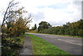
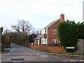
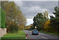
1
Junction of Sheppey Way and Stickfast Lane
The old A249.
Image: © N Chadwick
Taken: 30 Oct 2010
0.03 miles
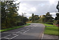
4
Road sign, Sheppey Way
The old route of the A249.
Image: © N Chadwick
Taken: 30 Oct 2010
0.04 miles
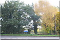
5
Sheppey Way, Howt Green
The old course of the A249.
Image: © N Chadwick
Taken: 30 Oct 2010
0.05 miles
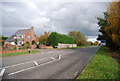
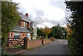
7
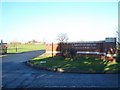
Entrance to Garden of England Crematorium
On Sheppey Way.
Image: © David Anstiss
Taken: 17 Dec 2008
0.08 miles