IMAGES TAKEN NEAR TO
Stickfast Lane, SITTINGBOURNE, ME9 8QL
Introduction
This page details the photographs taken nearby to Stickfast Lane, ME9 8QL by members of the Geograph project.
The Geograph project started in 2005 with the aim of publishing, organising and preserving representative images for every square kilometre of Great Britain, Ireland and the Isle of Man.

There are currently over 7.5m images from over14,400 individuals and you can help contribute to the project by visiting https://www.geograph.org.uk
Image Map
Images are licensed for reuse under creativecommons.org/licenses/by-sa/2.0
Notes
- Clicking on the map will re-center to the selected point.
- The higher the marker number, the further away the image location is from the centre of the postcode.
Image Listing (28 Images Found)
Images are licensed for reuse under creativecommons.org/licenses/by-sa/2.0
Image
Details
Distance
1
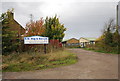
B. W. May and Sons. Co. Ltd, Stickfast Lane
Builders and Joiners.
Image: © N Chadwick
Taken: 30 Oct 2010
0.01 miles
3
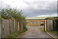
Cambray Works, Stickfast Lane
Builders and joiners works.
Image: © N Chadwick
Taken: 30 Oct 2010
0.02 miles
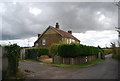
4
Rural Industry at Cambray Farm
A long established joinery company uses these farm buildings in a very rural spot.
Image: © Penny Mayes
Taken: 1 Jun 2005
0.03 miles
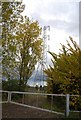
6
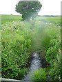
Brook near Cambray Farm
Looking SSW near the southern edge of the square.
Image: © Penny Mayes
Taken: 1 Jun 2005
0.06 miles
7
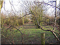
Derelict orchard
This orchard has been left to go wild, while in the next field, new trees have been planted.
Image: © Richard Dorrell
Taken: 27 Jan 2008
0.07 miles
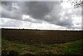
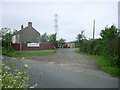
10
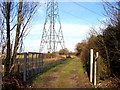
Track to Culnells
Photo taken looking north east from the junction with Stickfast Lane.
Although marked on the OS map as a public footpath, there were no footpath signs or waymarkers to be seen here.
Image: © Richard Dorrell
Taken: 27 Jan 2008
0.09 miles