IMAGES TAKEN NEAR TO
Belnor Avenue, SITTINGBOURNE, ME9 8QB
Introduction
This page details the photographs taken nearby to Belnor Avenue, ME9 8QB by members of the Geograph project.
The Geograph project started in 2005 with the aim of publishing, organising and preserving representative images for every square kilometre of Great Britain, Ireland and the Isle of Man.

There are currently over 7.5m images from over14,400 individuals and you can help contribute to the project by visiting https://www.geograph.org.uk
Image Map
Images are licensed for reuse under creativecommons.org/licenses/by-sa/2.0
Notes
- Clicking on the map will re-center to the selected point.
- The higher the marker number, the further away the image location is from the centre of the postcode.
Image Listing (6 Images Found)
Images are licensed for reuse under creativecommons.org/licenses/by-sa/2.0
Image
Details
Distance
1
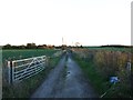
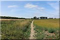
Footpath towards Great Norwood
Great Norwood is hidden by the trees on the left. The house in the photo does not seem to be shown on the OS map. The crop is oilseed rape. The orchard marked on the OS landranger map is gone.
Image: © Richard Dorrell
Taken: 29 Dec 2007
0.08 miles
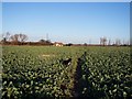
4
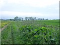
Ditch near Great Norwood
Looking south west from the north east corner of the square. The crop on the left is rape - not at all unusual.
Image: © Penny Mayes
Taken: 1 Jun 2005
0.21 miles