IMAGES TAKEN NEAR TO
Sheppey Way, SITTINGBOURNE, ME9 8PN
Introduction
This page details the photographs taken nearby to Sheppey Way, ME9 8PN by members of the Geograph project.
The Geograph project started in 2005 with the aim of publishing, organising and preserving representative images for every square kilometre of Great Britain, Ireland and the Isle of Man.

There are currently over 7.5m images from over14,400 individuals and you can help contribute to the project by visiting https://www.geograph.org.uk
Image Map
Images are licensed for reuse under creativecommons.org/licenses/by-sa/2.0
Notes
- Clicking on the map will re-center to the selected point.
- The higher the marker number, the further away the image location is from the centre of the postcode.
Image Listing (37 Images Found)
Images are licensed for reuse under creativecommons.org/licenses/by-sa/2.0
Image
Details
Distance
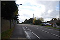
1
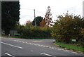
Parsonage Lane off Sheppey Way
The old A249.
Image: © N Chadwick
Taken: 30 Oct 2010
0.02 miles
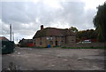
2
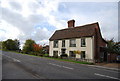
Luxton House, Bobbing
A Grade II listed building. http://www.britishlistedbuildings.co.uk/en-176034-laurelin-house-and-luxton-house-bobbing
Image: © N Chadwick
Taken: 30 Oct 2010
0.02 miles
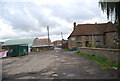
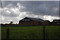
7
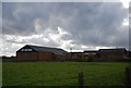
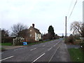
Church Farm
Now converted to a workshop.
Image: © N Chadwick
Taken: 30 Oct 2010
0.07 miles
8
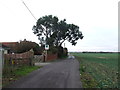
Bicycle lane, Sheppey Way, Bobbing
The old A249.
Image: © N Chadwick
Taken: 30 Oct 2010
0.07 miles
10
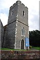
Church Tower, St Bartholomew's, Bobbing
Image: © N Chadwick
Taken: 30 Oct 2010
0.12 miles