IMAGES TAKEN NEAR TO
Bobbing Hill, SITTINGBOURNE, ME9 8PB
Introduction
This page details the photographs taken nearby to Bobbing Hill, ME9 8PB by members of the Geograph project.
The Geograph project started in 2005 with the aim of publishing, organising and preserving representative images for every square kilometre of Great Britain, Ireland and the Isle of Man.

There are currently over 7.5m images from over14,400 individuals and you can help contribute to the project by visiting https://www.geograph.org.uk
Image Map
Images are licensed for reuse under creativecommons.org/licenses/by-sa/2.0
Notes
- Clicking on the map will re-center to the selected point.
- The higher the marker number, the further away the image location is from the centre of the postcode.
Image Listing (27 Images Found)
Images are licensed for reuse under creativecommons.org/licenses/by-sa/2.0
Image
Details
Distance
2
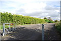
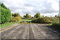
Sheppey Way, Bobbing
Old section of the A249 disused since the village of Bobbing was by-passed.
Image: © Chris Whippet
Taken: 25 Jan 2014
0.02 miles
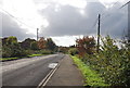
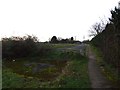
5
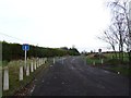
The end of the road
At one time this road carried on to join Sheppey Way.
Image: © N Chadwick
Taken: 30 Oct 2010
0.07 miles
6
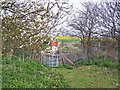
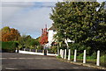
Footpath crosses railway
This crossing is over the Sittingbourne to London main line just west of Bobbing village.
Image: © Richard Dorrell
Taken: 4 Apr 2008
0.08 miles
9
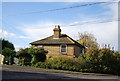
Sheppey Way, Bobbing
Old section of the A249 disused since the village of Bobbing was by-passed.
Image: © Chris Whippet
Taken: 25 Jan 2014
0.10 miles
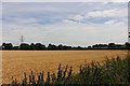
10
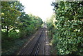
Railway line seen from Sheppey Way
The London to Margate line.
Image: © N Chadwick
Taken: 30 Oct 2010
0.10 miles