IMAGES TAKEN NEAR TO
Smiths Orchard, SITTINGBOURNE, ME9 8DS
Introduction
This page details the photographs taken nearby to Smiths Orchard, ME9 8DS by members of the Geograph project.
The Geograph project started in 2005 with the aim of publishing, organising and preserving representative images for every square kilometre of Great Britain, Ireland and the Isle of Man.

There are currently over 7.5m images from over14,400 individuals and you can help contribute to the project by visiting https://www.geograph.org.uk
Image Map
Images are licensed for reuse under creativecommons.org/licenses/by-sa/2.0
Notes
- Clicking on the map will re-center to the selected point.
- The higher the marker number, the further away the image location is from the centre of the postcode.
Image Listing (182 Images Found)
Images are licensed for reuse under creativecommons.org/licenses/by-sa/2.0
Image
Details
Distance
1
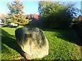
Stone in Jubilee Garden, Bredgar
The plaque explains that the Jubilee Garden was created in 2012 by the villagers of Bredgar to honour the Diamond Jubilee of Queen Elizabeth II. It is next to the footpath from Silver Street to The Street and St John the Baptist Church.
Image: © Marathon
Taken: 11 Nov 2023
0.03 miles
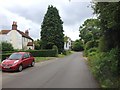
3
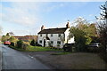
Lane End Cottage
This is at Silver Street, which is part of Bredgar.
Image: © Marathon
Taken: 11 Nov 2023
0.04 miles
5
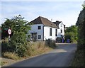
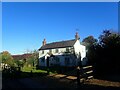
Wesley Cottage, Silver Street
I was puzzled by this building, one of just a few weather-boarded dwellings in this village and those nearby.
Later, looking at the photo I'd taken, I noticed the tall windows facing the street, and the regular layout of the end elevation. Tall windows might suggest that the building started off as a school - or, if north-facing, use as an artist's studio. But in this case I suspect that the name Wesley Cottage gives a hefty clue - this must have been a Methodist chapel.
As it happens, I'd Geographed something quite similar just a few weeks earlier: Image - not so many miles away. But I was weary as I walked along Silver Street - I'd been up at 5am and spent seven very warm hours tramping around Sheppey on the day of the Swale Barge Match. The penny didn't drop.
Image: © Stefan Czapski
Taken: 4 Aug 2018
0.04 miles

7
Holly Cottage, Silver Street
Holly Cottage is well-named in view of the large holly tree in front of it which was full of berries when this photograph was taken.
Image: © Marathon
Taken: 11 Nov 2023
0.05 miles
9
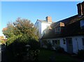
Chantry House across Gore Pond
The Chantry was founded in 1392. A History of the County of Kent says "Richard II on 19 July, 1392, granted licence for Master Robert de Bradegare and others to found at Bredgar a college of one chaplain and two clerk scholars who should serve God and celebrate divine service in the parish church of Bredgar at all times except when the said scholars were busy with their studies." The college succumbed to the dissolution of the monasteries in 1542.
In the first half of the 20th century it was inhabited as four cottages but has been a single private dwelling since the 1950s.
Chantry House is a grade II* listed building https://historicengland.org.uk/listing/the-list/list-entry/1069369
Image: © Penny Mayes
Taken: 8 Feb 2007
0.06 miles
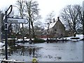
10
Recreation ground, Gore Road
With cricket pavilion recently painted green to comply with some new directive.
Image: © Penny Mayes
Taken: 29 Sep 2005
0.06 miles