IMAGES TAKEN NEAR TO
Blind Marys Lane, SITTINGBOURNE, ME9 8AR
Introduction
This page details the photographs taken nearby to Blind Marys Lane, ME9 8AR by members of the Geograph project.
The Geograph project started in 2005 with the aim of publishing, organising and preserving representative images for every square kilometre of Great Britain, Ireland and the Isle of Man.

There are currently over 7.5m images from over14,400 individuals and you can help contribute to the project by visiting https://www.geograph.org.uk
Image Map
Images are licensed for reuse under creativecommons.org/licenses/by-sa/2.0
Notes
- Clicking on the map will re-center to the selected point.
- The higher the marker number, the further away the image location is from the centre of the postcode.
Image Listing (20 Images Found)
Images are licensed for reuse under creativecommons.org/licenses/by-sa/2.0
Image
Details
Distance
2
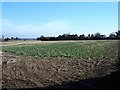
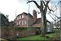
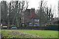
Cedar Cottage
This is the only house on Blind Mary's Lane and used to be a boarding cattery. The field does not seem to have been prepared for a crop yet, there is a pile of something http://www.geograph.org.uk/photo/326442 just out of shot to the left which will presumably be spread over it soon.
Image: © Penny Mayes
Taken: 31 Jan 2007
0.04 miles
3
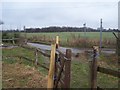
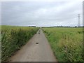
Footpath crosses Blind Mary's Lane
Footpath from Bicknor Lane, crosses through horses paddocks before crossing small road, to go through rape field to The Street, Silver Street.
Houses on left in background are part of Downsells Farm.
Image: © David Anstiss
Taken: 24 Feb 2009
0.06 miles
4
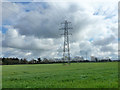
Pylon in field
The northern termination of this line is at a substation near Sittingbourne. It tees off an east-west route at its southern end.
Image: © Robin Webster
Taken: 4 Apr 2015
0.11 miles
6
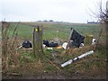
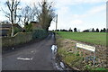
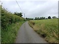
Flytipped rubbish on Blind Mary's Lane
At this point the lane takes a right-hand bend, so obvious place for flytippeds to dump their rubbish. Annoying for the farmer to clear up.
This footpath leads across a rape field to Dean's Hill Road.
Image: © David Anstiss
Taken: 24 Feb 2009
0.15 miles
7

View from Blind Mary's Lane
On a clear day you can see Southend - should you want to. I don't know what the heap of whitish material is on the corner of this field, some sort of field dressing (possibly waste from the local paper mills), I suppose, waiting to be spread. I do remember when there was a nice little orchard just here, one of two in what is now a huge field with little in the way of hedge around it. This point is around 120 metres above sea level and about 30 metres above Bredgar village. They get snow up here sometimes when the village remains clear.
Image: © Penny Mayes
Taken: 31 Jan 2007
0.16 miles