IMAGES TAKEN NEAR TO
Ruins Barn Road, SITTINGBOURNE, ME9 8AA
Introduction
This page details the photographs taken nearby to Ruins Barn Road, ME9 8AA by members of the Geograph project.
The Geograph project started in 2005 with the aim of publishing, organising and preserving representative images for every square kilometre of Great Britain, Ireland and the Isle of Man.

There are currently over 7.5m images from over14,400 individuals and you can help contribute to the project by visiting https://www.geograph.org.uk
Image Map
Images are licensed for reuse under creativecommons.org/licenses/by-sa/2.0
Notes
- Clicking on the map will re-center to the selected point.
- The higher the marker number, the further away the image location is from the centre of the postcode.
Image Listing (6 Images Found)
Images are licensed for reuse under creativecommons.org/licenses/by-sa/2.0
Image
Details
Distance
1
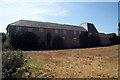
Oast House at Oakwood Farm, Sittingbourne, Kent
Image: © Oast House Archive
Taken: 19 Aug 2009
0.10 miles
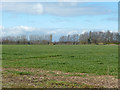
2
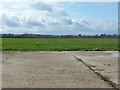
Field west of Ruins Barn Road
The road is behind the hedge on the right.
Image: © Robin Webster
Taken: 4 Apr 2015
0.17 miles
3
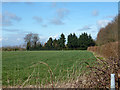
Footpath junction in Oakwood Farm
Path from Oakwood Cottages, on Tunstall Road leads beside hedge (on right hand side) to Ruins Barn Road. Also a path heads right, through field and then under M20 Motorway to lead to Bexon Lane, near Bredgar.
Image: © David Anstiss
Taken: 14 Jan 2009
0.19 miles
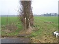
5
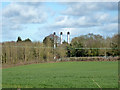
Three chimneys
On the Kent Science Park.
Image: © Robin Webster
Taken: 4 Apr 2015
0.23 miles