IMAGES TAKEN NEAR TO
Basser Hill, SITTINGBOURNE, ME9 7TY
Introduction
This page details the photographs taken nearby to Basser Hill, ME9 7TY by members of the Geograph project.
The Geograph project started in 2005 with the aim of publishing, organising and preserving representative images for every square kilometre of Great Britain, Ireland and the Isle of Man.

There are currently over 7.5m images from over14,400 individuals and you can help contribute to the project by visiting https://www.geograph.org.uk
Image Map
Images are licensed for reuse under creativecommons.org/licenses/by-sa/2.0
Notes
- Clicking on the map will re-center to the selected point.
- The higher the marker number, the further away the image location is from the centre of the postcode.
Image Listing (7 Images Found)
Images are licensed for reuse under creativecommons.org/licenses/by-sa/2.0
Image
Details
Distance
2
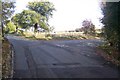
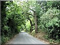
Junction on Sheerness Road
Sheerness Road leads from Lower Halstow towards Raspberry Hill Lane, towards Iwade. Basser Hill leads right.
Image: © David Anstiss
Taken: 7 Nov 2009
0.21 miles
3
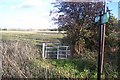
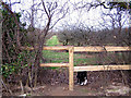
Kissing Gate on Saxon Shore Way
The long distance path leads from the road junction of Basser Hill and Sheerness Road. The path leads through a field past the Funton Brick Works.
Image: © David Anstiss
Taken: 7 Nov 2009
0.21 miles
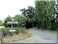
6
Footpath through orchard
The well maintained and waymarked footpath leads through this gap in the hedge into an apple orchard.
Image: © Richard Dorrell
Taken: 26 Jan 2008
0.24 miles
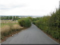
7
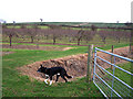
View from footpath junction
Basil the dog is checking out the immaculately maintained fences, ditches and trees alongside this footpath.
In the background is Callum Hill, with its strangely isolated pine tree.
Image: © Richard Dorrell
Taken: 26 Jan 2008
0.25 miles