IMAGES TAKEN NEAR TO
Place Lane, SITTINGBOURNE, ME9 7TR
Introduction
This page details the photographs taken nearby to Place Lane, ME9 7TR by members of the Geograph project.
The Geograph project started in 2005 with the aim of publishing, organising and preserving representative images for every square kilometre of Great Britain, Ireland and the Isle of Man.

There are currently over 7.5m images from over14,400 individuals and you can help contribute to the project by visiting https://www.geograph.org.uk
Image Map
Images are licensed for reuse under creativecommons.org/licenses/by-sa/2.0
Notes
- Clicking on the map will re-center to the selected point.
- The higher the marker number, the further away the image location is from the centre of the postcode.
Image Listing (16 Images Found)
Images are licensed for reuse under creativecommons.org/licenses/by-sa/2.0
Image
Details
Distance
1
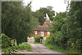
The Oast, Place Farm, Place Lane, Hartlip, Kent
Image: © Oast House Archive
Taken: 17 Aug 2008
0.08 miles
5

Yew tree Cottage, The Street, Hartlip
A 17th century, Grade II listed building. http://www.britishlistedbuildings.co.uk/en-176143-yew-tree-cottage-hartlip
Image: © N Chadwick
Taken: 30 Oct 2010
0.19 miles

9
Christmas trees
Acres of them, west of Warren Lane.
Image: © Penny Mayes
Taken: 19 Nov 2005
0.21 miles