IMAGES TAKEN NEAR TO
Mill Lane, SITTINGBOURNE, ME9 7TD
Introduction
This page details the photographs taken nearby to Mill Lane, ME9 7TD by members of the Geograph project.
The Geograph project started in 2005 with the aim of publishing, organising and preserving representative images for every square kilometre of Great Britain, Ireland and the Isle of Man.

There are currently over 7.5m images from over14,400 individuals and you can help contribute to the project by visiting https://www.geograph.org.uk
Image Map
Images are licensed for reuse under creativecommons.org/licenses/by-sa/2.0
Notes
- Clicking on the map will re-center to the selected point.
- The higher the marker number, the further away the image location is from the centre of the postcode.
Image Listing (26 Images Found)
Images are licensed for reuse under creativecommons.org/licenses/by-sa/2.0
Image
Details
Distance
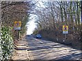
4
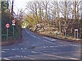
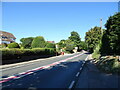
Junction of Mill Lane and Hartlip Hill
Mill lane leads into Hartlip village. Hartlip Hill is the A2.
Image: © Richard Dorrell
Taken: 9 Feb 2008
0.10 miles
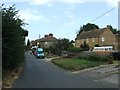
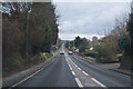
8
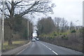
A2, Hartlip Hill
Looking east. About one mile behind me is Rainham, while the next village in this direction is Newington.
Image: © Richard Dorrell
Taken: 9 Feb 2008
0.13 miles