IMAGES TAKEN NEAR TO
Lower Hartlip Road, SITTINGBOURNE, ME9 7SZ
Introduction
This page details the photographs taken nearby to Lower Hartlip Road, ME9 7SZ by members of the Geograph project.
The Geograph project started in 2005 with the aim of publishing, organising and preserving representative images for every square kilometre of Great Britain, Ireland and the Isle of Man.

There are currently over 7.5m images from over14,400 individuals and you can help contribute to the project by visiting https://www.geograph.org.uk
Image Map
Images are licensed for reuse under creativecommons.org/licenses/by-sa/2.0
Notes
- Clicking on the map will re-center to the selected point.
- The higher the marker number, the further away the image location is from the centre of the postcode.
Image Listing (37 Images Found)
Images are licensed for reuse under creativecommons.org/licenses/by-sa/2.0
Image
Details
Distance
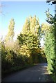
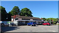
3
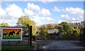
Entrance to the African Craft Centre, Lower Hartlip Rd
Image: © N Chadwick
Taken: 30 Oct 2010
0.04 miles
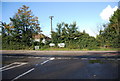
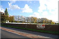
4
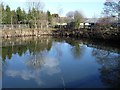
Duck pond at the Garden Centre
Lower Hartlip Road near its junction with the A2 London Road on the southern edge of the square.
Image: © Penny Mayes
Taken: 14 Feb 2006
0.07 miles