IMAGES TAKEN NEAR TO
Lower Hartlip Road, SITTINGBOURNE, ME9 7ST
Introduction
This page details the photographs taken nearby to Lower Hartlip Road, ME9 7ST by members of the Geograph project.
The Geograph project started in 2005 with the aim of publishing, organising and preserving representative images for every square kilometre of Great Britain, Ireland and the Isle of Man.

There are currently over 7.5m images from over14,400 individuals and you can help contribute to the project by visiting https://www.geograph.org.uk
Image Map
Images are licensed for reuse under creativecommons.org/licenses/by-sa/2.0
Notes
- Clicking on the map will re-center to the selected point.
- The higher the marker number, the further away the image location is from the centre of the postcode.
Image Listing (101 Images Found)
Images are licensed for reuse under creativecommons.org/licenses/by-sa/2.0
Image
Details
Distance
4
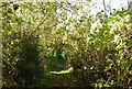
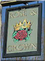
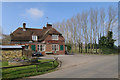
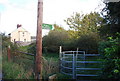
Footpath on Lower Hartlip Road
Footpath leads to Chelsey/Newington through pony paddock and orchards.
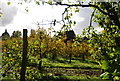
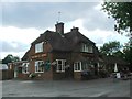
Rose and Crown pubsign (green) seen in background on road to Hartlip.
Image: © David Anstiss
Taken: 27 Nov 2008
0.04 miles