IMAGES TAKEN NEAR TO
Old House Lane, SITTINGBOURNE, ME9 7SP
Introduction
This page details the photographs taken nearby to Old House Lane, ME9 7SP by members of the Geograph project.
The Geograph project started in 2005 with the aim of publishing, organising and preserving representative images for every square kilometre of Great Britain, Ireland and the Isle of Man.

There are currently over 7.5m images from over14,400 individuals and you can help contribute to the project by visiting https://www.geograph.org.uk
Image Map
Images are licensed for reuse under creativecommons.org/licenses/by-sa/2.0
Notes
- Clicking on the map will re-center to the selected point.
- The higher the marker number, the further away the image location is from the centre of the postcode.
Image Listing (15 Images Found)
Images are licensed for reuse under creativecommons.org/licenses/by-sa/2.0
Image
Details
Distance
1
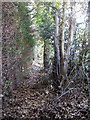
Footpath at Scotts Hill, Lower Hartlip
A little used path between Auger's yard and a private garden, squeezed between the old hedge-line on the right and the new leylandii hedge on the left.
Image: © Penny Mayes
Taken: 14 Feb 2006
0.16 miles
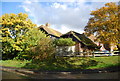
2
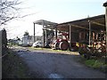
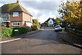
Agricultural Equipment, Lower Hartlip
Contractor's storage barns.
Image: © Penny Mayes
Taken: 14 Feb 2006
0.16 miles
3
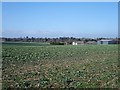
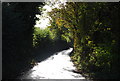
Sweepstakes Farm, Hartlip
Looking WNW from Old House Lane.
Image: © Penny Mayes
Taken: 14 Feb 2006
0.17 miles
6
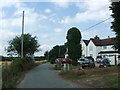
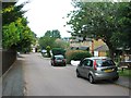
House at Old House Rd, Lower Hartlip Rd junction
Image: © N Chadwick
Taken: 30 Oct 2010
0.22 miles
7
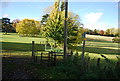
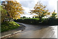
Footpath off Lower Hartlip Rd
Footpath to the village of Hartlip.
Image: © N Chadwick
Taken: 30 Oct 2010
0.22 miles