IMAGES TAKEN NEAR TO
Bimbury Lane, SITTINGBOURNE, ME9 7QX
Introduction
This page details the photographs taken nearby to Bimbury Lane, ME9 7QX by members of the Geograph project.
The Geograph project started in 2005 with the aim of publishing, organising and preserving representative images for every square kilometre of Great Britain, Ireland and the Isle of Man.

There are currently over 7.5m images from over14,400 individuals and you can help contribute to the project by visiting https://www.geograph.org.uk
Image Map
Images are licensed for reuse under creativecommons.org/licenses/by-sa/2.0
Notes
- Clicking on the map will re-center to the selected point.
- The higher the marker number, the further away the image location is from the centre of the postcode.
Image Listing (24 Images Found)
Images are licensed for reuse under creativecommons.org/licenses/by-sa/2.0
Image
Details
Distance
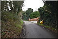
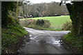
3
Footpath to Beaux Aires Wood
From Yelsted road to Park Valley on Cox Street.
Image: © David Anstiss
Taken: 5 Dec 2008
0.06 miles
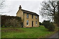
10
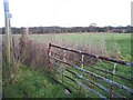
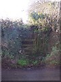
Blocked Footpath
On Binbury Lane, should lead to South Street Road. Opposite Beaux Aires Farm cottage, which had several big and noisy barking dogs. Possible reason for blocking the footpath and barded wire on the gate, so not possible to climb over..
Image: © David Anstiss
Taken: 5 Dec 2008
0.15 miles