IMAGES TAKEN NEAR TO
Woodgate Lane, SITTINGBOURNE, ME9 7QB
Introduction
This page details the photographs taken nearby to Woodgate Lane, ME9 7QB by members of the Geograph project.
The Geograph project started in 2005 with the aim of publishing, organising and preserving representative images for every square kilometre of Great Britain, Ireland and the Isle of Man.

There are currently over 7.5m images from over14,400 individuals and you can help contribute to the project by visiting https://www.geograph.org.uk
Image Map (Loading...)


Getting Data...Please wait
Leaflet Map data © OpenStreetMap
Images are licensed for reuse under creativecommons.org/licenses/by-sa/2.0
Notes
- Clicking on the map will re-center to the selected point.
- The higher the marker number, the further away the image location is from the centre of the postcode.
Image Listing (14 Images Found)
Images are licensed for reuse under creativecommons.org/licenses/by-sa/2.0
Image
Details
Distance
2
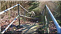
Unmapped steps
These steps down from Wormdale Hill road towards Danaway are not shown on either the 1:25000 or 1:50000 Ordnance Survey (nor Google) maps. From their nature it is suspected that they were installed as part of the expansion of the A249.
Image: © Tony Hunt
Taken: 28 Jan 2016
0.13 miles
3
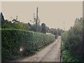
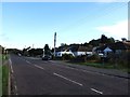
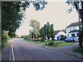
Danaway
The A249 used to go right through this hamlet but the new road bypasses it ... just.
Image: © Penny Mayes
Taken: 16 Apr 2005
0.14 miles
7
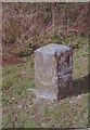
Old Milestone by Maidstone Road, Danaway, Borden parish
Carved stone post by the UC road (was A249), in parish of Borden (Swale District), Maidstone Road, opposite "Greenlands", just South of bus shelter, on wide grass verge, on West side of road. Sittingbourne stone, erected by the Maidstone & Key Street turnpike trust in the 19th century.
Inscription reads:-
: 3 / MILES / TO / SITTINGBOURNE : : (8) / MILES / TO / MAIDSTONE :
Kent HER.
HER Number: TQ 86 SE 249 https://www.heritagegateway.org.uk/Gateway/Results_Single.aspx?uid=MKE78194&resourceID=1005
Milestone Society National ID: KE_SBMD03
Image: © C Woodward
Taken: 26 Mar 2009
0.16 miles
9
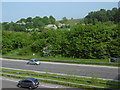
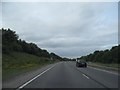
Looking across the A249 Maidstone Road
The A249 is now a fast dual carriageway leading to Sheerness and the Isle of Sheppey. Before the new road was built, the A249 passed through Chestnut Street to the east as the 1961 Ordnance Survey map showed - http://maps.nls.uk/geo/explore/#zoom=14&lat=51.3375&lon=0.6746&layers=11
This is the view from Wormdale Hill. Danaway is on the far side.
Image: © Marathon
Taken: 28 May 2016
0.18 miles