IMAGES TAKEN NEAR TO
Breach Lane, SITTINGBOURNE, ME9 7PE
Introduction
This page details the photographs taken nearby to Breach Lane, ME9 7PE by members of the Geograph project.
The Geograph project started in 2005 with the aim of publishing, organising and preserving representative images for every square kilometre of Great Britain, Ireland and the Isle of Man.

There are currently over 7.5m images from over14,400 individuals and you can help contribute to the project by visiting https://www.geograph.org.uk
Image Map
Images are licensed for reuse under creativecommons.org/licenses/by-sa/2.0
Notes
- Clicking on the map will re-center to the selected point.
- The higher the marker number, the further away the image location is from the centre of the postcode.
Image Listing (25 Images Found)
Images are licensed for reuse under creativecommons.org/licenses/by-sa/2.0
Image
Details
Distance
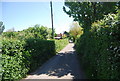
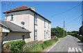
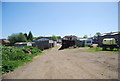
1
Breach village
Taken from the entrance to Breach Farm.
Image: © Richard Dorrell
Taken: 9 Feb 2008
0.01 miles
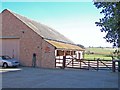
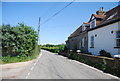
4
Breach Cottage, Breach Lane
A whitewashed, stone built cottage.
Image: © N Chadwick
Taken: 23 May 2010
0.04 miles
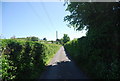
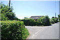
7
Lane leading to Newington near its junction with Breach Lane.
Image: © pam fray
Taken: 10 May 2009
0.06 miles
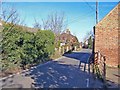
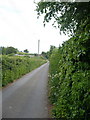
9
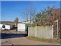
Footpath into Kaine Farm, Breach
With a loudly barking dog somewhere among these sheds, I did not venture through the gate to explore this signposted footpath
Image: © Richard Dorrell
Taken: 9 Feb 2008
0.07 miles