IMAGES TAKEN NEAR TO
Playstool Road, SITTINGBOURNE, ME9 7NE
Introduction
This page details the photographs taken nearby to Playstool Road, ME9 7NE by members of the Geograph project.
The Geograph project started in 2005 with the aim of publishing, organising and preserving representative images for every square kilometre of Great Britain, Ireland and the Isle of Man.

There are currently over 7.5m images from over14,400 individuals and you can help contribute to the project by visiting https://www.geograph.org.uk
Image Map
Images are licensed for reuse under creativecommons.org/licenses/by-sa/2.0
Notes
- Clicking on the map will re-center to the selected point.
- The higher the marker number, the further away the image location is from the centre of the postcode.
Image Listing (58 Images Found)
Images are licensed for reuse under creativecommons.org/licenses/by-sa/2.0
Image
Details
Distance
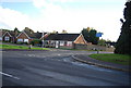
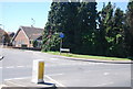
6
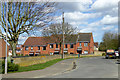
Houses on Dennis Willcocks Close
In the even newer part of Newington.
Image: © Robin Webster
Taken: 21 Mar 2017
0.13 miles
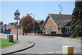
10
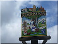
Close up of Newington village sign
The Roman soldier indicates that Newington straddles the old Roman road of Watling Street. Hop pickers, sheep and a runner also feature.
For its setting see http://www.geograph.org.uk/photo/4446491
Image: © Marathon
Taken: 25 Apr 2015
0.15 miles