IMAGES TAKEN NEAR TO
Bull Lane, SITTINGBOURNE, ME9 7NB
Introduction
This page details the photographs taken nearby to Bull Lane, ME9 7NB by members of the Geograph project.
The Geograph project started in 2005 with the aim of publishing, organising and preserving representative images for every square kilometre of Great Britain, Ireland and the Isle of Man.

There are currently over 7.5m images from over14,400 individuals and you can help contribute to the project by visiting https://www.geograph.org.uk
Image Map
Images are licensed for reuse under creativecommons.org/licenses/by-sa/2.0
Notes
- Clicking on the map will re-center to the selected point.
- The higher the marker number, the further away the image location is from the centre of the postcode.
Image Listing (14 Images Found)
Images are licensed for reuse under creativecommons.org/licenses/by-sa/2.0
Image
Details
Distance
1
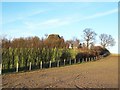
Footpath up Standard Hill
The footpath runs between the wire fence and the hedge.
Image: © Richard Dorrell
Taken: 12 Jan 2008
0.08 miles
6
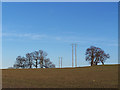
Trees and wires
On Standard Hill near Newington
Image: © Richard Dorrell
Taken: 12 Jan 2008
0.23 miles
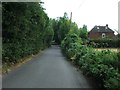
9
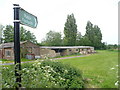
Start of the footpath to Lower Hartlip
Off Bull Lane and south of Gwelo Farm.
Image: © pam fray
Taken: 10 May 2009
0.23 miles
10
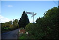
Road sign, Bull Lane, Wormdale Rd junction
Image: © N Chadwick
Taken: 30 Oct 2010
0.23 miles