IMAGES TAKEN NEAR TO
Iwade Road, SITTINGBOURNE, ME9 7JY
Introduction
This page details the photographs taken nearby to Iwade Road, ME9 7JY by members of the Geograph project.
The Geograph project started in 2005 with the aim of publishing, organising and preserving representative images for every square kilometre of Great Britain, Ireland and the Isle of Man.

There are currently over 7.5m images from over14,400 individuals and you can help contribute to the project by visiting https://www.geograph.org.uk
Image Map
Images are licensed for reuse under creativecommons.org/licenses/by-sa/2.0
Notes
- Clicking on the map will re-center to the selected point.
- The higher the marker number, the further away the image location is from the centre of the postcode.
Image Listing (81 Images Found)
Images are licensed for reuse under creativecommons.org/licenses/by-sa/2.0
Image
Details
Distance
1
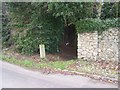
Footpath beside Oak Manor
On Iwade Road, leads through woodland to Wardwell Lane.
Image: © David Anstiss
Taken: 27 Dec 2008
0.03 miles
2
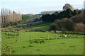
Newington countryside
View from the eastern end of the church of St. Mary the Virgin, Newington.
Image: © pam fray
Taken: 1 Dec 2009
0.07 miles
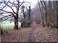
3
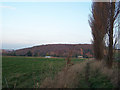
Footpath towards Hawes Wood
Viewed looking north. The railway crossing is immediately behind the photographer. A seldom-used footpath. The house at the bottom is called "Snakesbury".
Image: © Richard Dorrell
Taken: 16 Dec 2007
0.10 miles
5
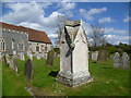
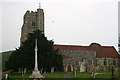
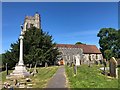
The churchyard of St Mary's Church, Newington
John Newman in Pevsner's Kent volume of the Buildings of England describes the tower of St Mary's as "among the finest of these characteristically Kentish ones." It is also well-known at apple blossom time as it rises above a sea of blossom. This interesting grave is next to the main path leading to the south door.
Image: © Marathon
Taken: 25 Apr 2015
0.11 miles
6
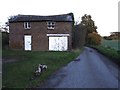
Old barn on High Oak Hill near Newington
Image: © Chris Whippet
Taken: 11 Nov 2013
0.11 miles
7
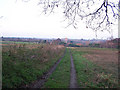
Looking West towards Newington
This track is a public footpath, though seldom used.
Image: © Richard Dorrell
Taken: 16 Dec 2007
0.11 miles
8
Footpath through Wardwell Wood
Running just north of Newington Church, a mistake on the OS map shows this path to lie outside of the boundary of the wood. Clearly, it doesn't! The wood is mostly chestnut, with a few mature oak. Bluebells carpet the wood in spring.
Image: © Richard Dorrell
Taken: 24 Dec 2007
0.12 miles
9
Newington St Mary's Church
There is an Ordnance Survey benchmark Image on the side of the porch.
Image: © Luke Shaw
Taken: 10 Jun 2020
0.12 miles
10
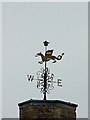
Weather vane on St Mary's Church
This ornate weather vane tops the tower of St Mary's Church in Newington. It looks to have on it the letters RSDC and date 1804, but I have been unable to find online any information about it. Any ideas anyone?
Image: © Richard Dorrell
Taken: 24 Mar 2008
0.12 miles