IMAGES TAKEN NEAR TO
St. Marys View, SITTINGBOURNE, ME9 7JW
Introduction
This page details the photographs taken nearby to St. Marys View, ME9 7JW by members of the Geograph project.
The Geograph project started in 2005 with the aim of publishing, organising and preserving representative images for every square kilometre of Great Britain, Ireland and the Isle of Man.

There are currently over 7.5m images from over14,400 individuals and you can help contribute to the project by visiting https://www.geograph.org.uk
Image Map
Images are licensed for reuse under creativecommons.org/licenses/by-sa/2.0
Notes
- Clicking on the map will re-center to the selected point.
- The higher the marker number, the further away the image location is from the centre of the postcode.
Image Listing (116 Images Found)
Images are licensed for reuse under creativecommons.org/licenses/by-sa/2.0
Image
Details
Distance
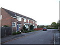
6
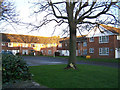
Vicarage Court
Located in Church Lane, this is a private residential home for the elderly.
Image: © Richard Dorrell
Taken: 29 Dec 2007
0.08 miles
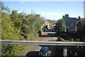
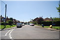
10
Lower Newington
Looking east towards the church (just out of view on the left) from the footpath that crosses School Lane http://www.geograph.org.uk/photo/114208 . The railway line runs between the double row of poplars - see Image
Image: © Penny Mayes
Taken: 29 Jan 2006
0.09 miles