IMAGES TAKEN NEAR TO
Oak Lane, SITTINGBOURNE, ME9 7FB
Introduction
This page details the photographs taken nearby to Oak Lane, ME9 7FB by members of the Geograph project.
The Geograph project started in 2005 with the aim of publishing, organising and preserving representative images for every square kilometre of Great Britain, Ireland and the Isle of Man.

There are currently over 7.5m images from over14,400 individuals and you can help contribute to the project by visiting https://www.geograph.org.uk
Image Map
Images are licensed for reuse under creativecommons.org/licenses/by-sa/2.0
Notes
- Clicking on the map will re-center to the selected point.
- The higher the marker number, the further away the image location is from the centre of the postcode.
Image Listing (40 Images Found)
Images are licensed for reuse under creativecommons.org/licenses/by-sa/2.0
Image
Details
Distance
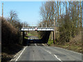
2
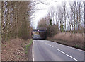
Oak Lane railway bridge
Looking north. Oak lane is the main link between the A2 and the village of Upchurch.
Image: © Richard Dorrell
Taken: 20 Jan 2008
0.05 miles
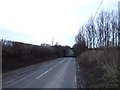
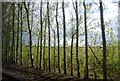
4
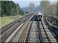
Railway bridge over Oak Lane
Four tracks cross, which seem to be a double track main line plus long passing loops.
Image: © Robin Webster
Taken: 16 Feb 2014
0.06 miles
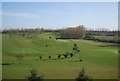
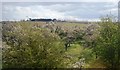
8
Chatham Main Line
Looking East from Seymour Road.
Image: © Oast House Archive
Taken: 17 Mar 2016
0.10 miles