IMAGES TAKEN NEAR TO
The Potteries, SITTINGBOURNE, ME9 7AF
Introduction
This page details the photographs taken nearby to The Potteries, ME9 7AF by members of the Geograph project.
The Geograph project started in 2005 with the aim of publishing, organising and preserving representative images for every square kilometre of Great Britain, Ireland and the Isle of Man.

There are currently over 7.5m images from over14,400 individuals and you can help contribute to the project by visiting https://www.geograph.org.uk
Image Map
Images are licensed for reuse under creativecommons.org/licenses/by-sa/2.0
Notes
- Clicking on the map will re-center to the selected point.
- The higher the marker number, the further away the image location is from the centre of the postcode.
Image Listing (81 Images Found)
Images are licensed for reuse under creativecommons.org/licenses/by-sa/2.0
Image
Details
Distance
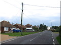
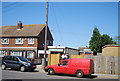
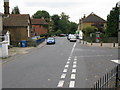
4
Upchurch
Junction of Horsham Lane (foreground) with Oak Lane.
Image: © Penny Mayes
Taken: 19 Nov 2005
0.09 miles
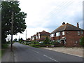
5
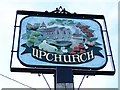
Upchurch village sign
Erected for the centenary of the Parish Council 1994.
Image: © Penny Mayes
Taken: 19 Nov 2005
0.09 miles
6
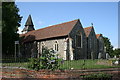
St Mary the Virgin Church, Upchurch
Magnificent Parish Church dating from 16th Century
Image: © Steve Wheeler
Taken: 2 Sep 2005
0.09 miles
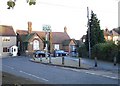
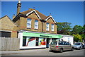
7
Post Office, The Street
A combined post office and newsagents.
Image: © N Chadwick
Taken: 23 May 2010
0.09 miles
10
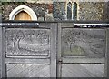
Gates of St Mary the Virgin, Upchurch
Nicely carved panels "Community is an orchard, a river, a sea"
Image: © Penny Mayes
Taken: 19 Nov 2005
0.10 miles