IMAGES TAKEN NEAR TO
Forge Lane, SITTINGBOURNE, ME9 7AD
Introduction
This page details the photographs taken nearby to Forge Lane, ME9 7AD by members of the Geograph project.
The Geograph project started in 2005 with the aim of publishing, organising and preserving representative images for every square kilometre of Great Britain, Ireland and the Isle of Man.

There are currently over 7.5m images from over14,400 individuals and you can help contribute to the project by visiting https://www.geograph.org.uk
Image Map
Images are licensed for reuse under creativecommons.org/licenses/by-sa/2.0
Notes
- Clicking on the map will re-center to the selected point.
- The higher the marker number, the further away the image location is from the centre of the postcode.
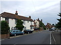
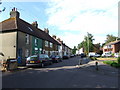
Image Listing (63 Images Found)
Images are licensed for reuse under creativecommons.org/licenses/by-sa/2.0
Image
Details
Distance
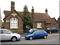
2
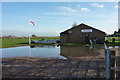
A rather waterlogged entrance to Upchurch sports centre
The building displays the logo of Orange Cricket, suppliers of sportswear.
Image: © pam fray
Taken: 1 Dec 2009
0.06 miles
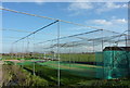
3
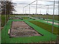
Cricket nets, Upchurch
Re-turfing seems to be in progress here. I'm impressed by a small village club boasting eight nets!
Image: © Penny Mayes
Taken: 14 Feb 2006
0.11 miles
5
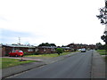
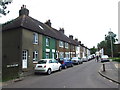
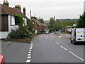
Forge Lane
Leading out of Upchurch towards Lower Halstow.
Image: © Ian Capper
Taken: 9 Jul 2013
0.13 miles