IMAGES TAKEN NEAR TO
Halstow Lane, SITTINGBOURNE, ME9 7AB
Introduction
This page details the photographs taken nearby to Halstow Lane, ME9 7AB by members of the Geograph project.
The Geograph project started in 2005 with the aim of publishing, organising and preserving representative images for every square kilometre of Great Britain, Ireland and the Isle of Man.

There are currently over 7.5m images from over14,400 individuals and you can help contribute to the project by visiting https://www.geograph.org.uk
Image Map
Images are licensed for reuse under creativecommons.org/licenses/by-sa/2.0
Notes
- Clicking on the map will re-center to the selected point.
- The higher the marker number, the further away the image location is from the centre of the postcode.
Image Listing (8 Images Found)
Images are licensed for reuse under creativecommons.org/licenses/by-sa/2.0
Image
Details
Distance
1
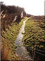
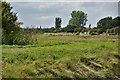
Parish boundary, Lower Halstow
This brook forms the boundary between Upchurch and Lower Halstow and becomes Twinney Creek once it reaches the mudflats of the estuary. It runs along the western edge of the old brickworks site http://www.geograph.org.uk/photo/115424
Image: © Penny Mayes
Taken: 29 Jan 2006
0.18 miles
3
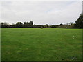
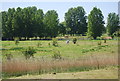
Memorial field, Lower Halstow
This piece of open land, is about to become a memorial field, with a statue and avenue of trees planted (where the sticks are).
Image: © David Anstiss
Taken: 25 Oct 2014
0.20 miles
4
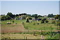
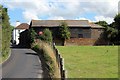
Frog Farm
Looking west from the Saxon Shore Way north of Lower Halstow.
Image: © Penny Mayes
Taken: 29 Jan 2006
0.22 miles