IMAGES TAKEN NEAR TO
School Lane, SITTINGBOURNE, ME9 0SJ
Introduction
This page details the photographs taken nearby to School Lane, ME9 0SJ by members of the Geograph project.
The Geograph project started in 2005 with the aim of publishing, organising and preserving representative images for every square kilometre of Great Britain, Ireland and the Isle of Man.

There are currently over 7.5m images from over14,400 individuals and you can help contribute to the project by visiting https://www.geograph.org.uk
Image Map
Images are licensed for reuse under creativecommons.org/licenses/by-sa/2.0
Notes
- Clicking on the map will re-center to the selected point.
- The higher the marker number, the further away the image location is from the centre of the postcode.
Image Listing (6 Images Found)
Images are licensed for reuse under creativecommons.org/licenses/by-sa/2.0
Image
Details
Distance
1
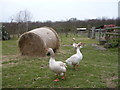
Geese in a field opposite Milstead Primary School
Image: © pam fray
Taken: 24 Mar 2008
0.07 miles
2
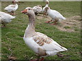
Geese in a field opposite Milstead Primary School
This unusually friendly goose seemed happy to pose for its photograph.
Image: © pam fray
Taken: 24 Mar 2008
0.07 miles
3
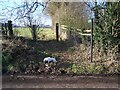
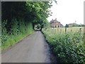
Footpath on Frinsted Road
Path leads from near Milstead Manor Farm to Bottom Pond Road, near Cosy Cottage.
Image: © David Anstiss
Taken: 29 Jan 2009
0.10 miles