IMAGES TAKEN NEAR TO
Rawling Street, SITTINGBOURNE, ME9 0RX
Introduction
This page details the photographs taken nearby to Rawling Street, ME9 0RX by members of the Geograph project.
The Geograph project started in 2005 with the aim of publishing, organising and preserving representative images for every square kilometre of Great Britain, Ireland and the Isle of Man.

There are currently over 7.5m images from over14,400 individuals and you can help contribute to the project by visiting https://www.geograph.org.uk
Image Map
Images are licensed for reuse under creativecommons.org/licenses/by-sa/2.0
Notes
- Clicking on the map will re-center to the selected point.
- The higher the marker number, the further away the image location is from the centre of the postcode.
Image Listing (37 Images Found)
Images are licensed for reuse under creativecommons.org/licenses/by-sa/2.0
Image
Details
Distance
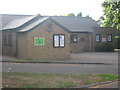
2
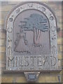
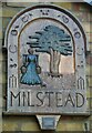
Milstead Village Sign on Village Hall
Carved wooden sign on the village hall (seen in Image).
Has small metal plaque below which reads 'The Village sign, carved by Mr. Norman Smithers, was unveiled by Cllr. Jean Newman on 11th September 1993'.
The name Milstead describes a 'milk place', hence milk maid on sign.
Image: © David Anstiss
Taken: 27 Aug 2009
0.03 miles
3
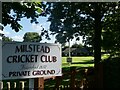
Milstead Cricket Club ground and pavilion
The entrance is in Rawling Street, opposite the Village Hall.
Image: © pam fray
Taken: 10 Aug 2021
0.04 miles
4
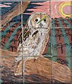
Ceramic tiles round the base of the Village Hall, Milstead
One set of 26, one for each letter of the alphabet, created by local people. This is one of 8 contributed by Nigel Hobbins.
Image: © pam fray
Taken: 10 Aug 2021
0.04 miles
5
Village sign, Milstead
A wooden sign on the wall of the Village Hall. The plaque beneath states that it was carved by Mr. Norman Smithers and unveiled by Cllr. Jean Newman in 1993.
Image: © pam fray
Taken: 10 Aug 2021
0.04 miles
6

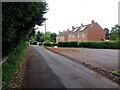
Rose Cottage, Milstead
On Frinsted Road, opposite the village hall.
Image: © David Anstiss
Taken: 27 Aug 2009
0.05 miles
8
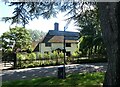
Signpost and cottage, Milstead
Northwards, Rawling Street leads to Sittingbourne, southwards Frinsted Road leads to Frinsted and Doddington. Rose Cottage is a Grade II listed building.
Image: © pam fray
Taken: 10 Aug 2021
0.06 miles
9
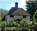
Rose Cottage, Milstead
On Rawling Street, a Grade II listed building.
Image: © pam fray
Taken: 10 Aug 2021
0.06 miles
10
Milstead Village Hall
On the junction of Frinsted Road (in front) and Horn Hill (on the left).
On a gable end is a map of footpaths, information board and Village sign.
Image: © David Anstiss
Taken: 27 Aug 2009
0.07 miles