IMAGES TAKEN NEAR TO
Lynsted Lane, SITTINGBOURNE, ME9 0RL
Introduction
This page details the photographs taken nearby to Lynsted Lane, ME9 0RL by members of the Geograph project.
The Geograph project started in 2005 with the aim of publishing, organising and preserving representative images for every square kilometre of Great Britain, Ireland and the Isle of Man.

There are currently over 7.5m images from over14,400 individuals and you can help contribute to the project by visiting https://www.geograph.org.uk
Image Map (Loading...)


Getting Data...Please wait
Leaflet Map data © OpenStreetMap
Images are licensed for reuse under creativecommons.org/licenses/by-sa/2.0
Notes
- Clicking on the map will re-center to the selected point.
- The higher the marker number, the further away the image location is from the centre of the postcode.
Image Listing (83 Images Found)
Images are licensed for reuse under creativecommons.org/licenses/by-sa/2.0
Image
Details
Distance
2
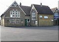
Lynsted and Norton Primary School, Lynsted Lane
Image: © pam fray
Taken: 3 Feb 2008
0.03 miles
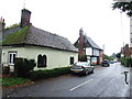
3
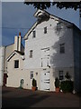
House on the corner of Lynsted Lane and Claxfield Road
Image: © pam fray
Taken: 3 Feb 2008
0.05 miles
4
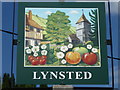
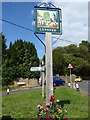
The village sign for Lynsted
The sign is to be found where Claxfield Road meets The Street, just north of the church. The sign shows a very idealised Kentish scene with apples, cherries, the church, an old half-timbered house and the Downs. The setting of the sign can be seen at https://www.geograph.org.uk/photo/6191506 Compare this with the sign for nearby Kingsdown https://www.geograph.org.uk/photo/6191559
Image: © Marathon
Taken: 21 Jun 2019
0.05 miles
5
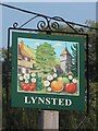
The village sign for Lynsted
The sign is to be found where Claxfield Road meets The Street, just north of the church. The sign shows a very idealised Kentish scene with apples, cherries, the church, an old half-timbered house and the Downs. A close up of the sign can be seen at https://www.geograph.org.uk/photo/6191511
Image: © Marathon
Taken: 21 Jun 2019
0.05 miles
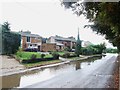
7
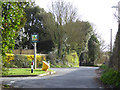
Entering Lynsted
Claxfield Road and Lynsted Lane meet and become The Street.
Image: © Robin Webster
Taken: 21 Mar 2017
0.06 miles
8
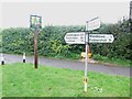
Village Sign and Finger Post, Lynsted
Image: © Chris Whippet
Taken: 13 Oct 2013
0.06 miles
10
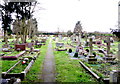
The graveyard, Lynsted
This is an extension to the churchyard north of the village on The Street.
Image: © pam fray
Taken: 3 Feb 2016
0.11 miles