IMAGES TAKEN NEAR TO
Doddington, SITTINGBOURNE, ME9 0NX
Introduction
This page details the photographs taken nearby to ME9 0NX by members of the Geograph project.
The Geograph project started in 2005 with the aim of publishing, organising and preserving representative images for every square kilometre of Great Britain, Ireland and the Isle of Man.

There are currently over 7.5m images from over14,400 individuals and you can help contribute to the project by visiting https://www.geograph.org.uk
Image Map
Images are licensed for reuse under creativecommons.org/licenses/by-sa/2.0
Notes
- Clicking on the map will re-center to the selected point.
- The higher the marker number, the further away the image location is from the centre of the postcode.
Image Listing (7 Images Found)
Images are licensed for reuse under creativecommons.org/licenses/by-sa/2.0
Image
Details
Distance
1
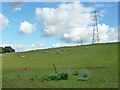
Sheep on Sprats Hill
East of Old Lenham Road.
Image: © Robin Webster
Taken: 8 Oct 2015
0.13 miles
2
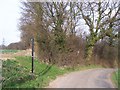
Footpath into Jackson's Wood
Path leads on edge of field before going through woodland leading to Hope's Hill, Doddington.
Image: © David Anstiss
Taken: 24 Mar 2009
0.14 miles
4
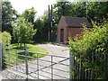
Small building on Old Lenham Road
Electricity, telephone or water related? No identifying signs but that seems to be the norm these days. It is not marked on the map.
Image: © Penny Mayes
Taken: 8 Jun 2006
0.20 miles
5
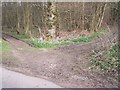
Byway on Old Lenham Road
The byway (on right) goes through King's Acre wood to Sprats Hill road.
The path on the left is just a woodland track into wood for coppicers.
Image: © David Anstiss
Taken: 24 Mar 2009
0.20 miles
6
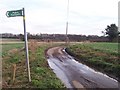
Footpaths on Sprats Hill road
Path closest leads through rape field then over lane into Jackson's Wood then onto Hope's Hill, Doddington. Path further along the road leads through rape field to Slade Road and then onto Sparks Wood.
Image: © David Anstiss
Taken: 24 Mar 2009
0.23 miles
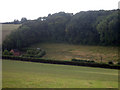
7
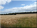
Crop field near Doddington
Probably part of Temple Farm. Viewed from the path skirting Jackson's Wood.
Image: © pam fray
Taken: 28 Jul 2020
0.24 miles