IMAGES TAKEN NEAR TO
Sharsted Hill, SITTINGBOURNE, ME9 0LT
Introduction
This page details the photographs taken nearby to Sharsted Hill, ME9 0LT by members of the Geograph project.
The Geograph project started in 2005 with the aim of publishing, organising and preserving representative images for every square kilometre of Great Britain, Ireland and the Isle of Man.

There are currently over 7.5m images from over14,400 individuals and you can help contribute to the project by visiting https://www.geograph.org.uk
Image Map
Images are licensed for reuse under creativecommons.org/licenses/by-sa/2.0
Notes
- Clicking on the map will re-center to the selected point.
- The higher the marker number, the further away the image location is from the centre of the postcode.
Image Listing (65 Images Found)
Images are licensed for reuse under creativecommons.org/licenses/by-sa/2.0
Image
Details
Distance

8
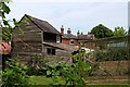
Weatherboarded barn off The Street
Image: © Oast House Archive
Taken: 2 Jun 2019
0.05 miles
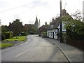
10
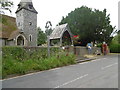
The Church of St Peter and St Paul, Newnham
John Newman in The Buildings of England: North-East and East Kent says of the church: "The shape is old; that is all one can say after the restoration of 1868."
Image: © Marathon
Taken: 7 Jul 2016
0.06 miles