IMAGES TAKEN NEAR TO
Newnham Valley, SITTINGBOURNE, ME9 0LB
Introduction
This page details the photographs taken nearby to Newnham Valley, ME9 0LB by members of the Geograph project.
The Geograph project started in 2005 with the aim of publishing, organising and preserving representative images for every square kilometre of Great Britain, Ireland and the Isle of Man.

There are currently over 7.5m images from over14,400 individuals and you can help contribute to the project by visiting https://www.geograph.org.uk
Image Map
Images are licensed for reuse under creativecommons.org/licenses/by-sa/2.0
Notes
- Clicking on the map will re-center to the selected point.
- The higher the marker number, the further away the image location is from the centre of the postcode.
Image Listing (2 Images Found)
Images are licensed for reuse under creativecommons.org/licenses/by-sa/2.0
Image
Details
Distance
1
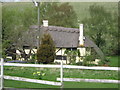
Whitehall Cottage
Thatched cottage on Faversham Road. As seen from footpath from Faversham Road to Elverland Farm.
Image: © David Anstiss
Taken: 23 Apr 2009
0.02 miles
2
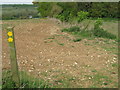
Footpath junction near College Wood
Path from Elverland Farm on Elverland Lane, leads downhill to Faversham Road, past Whitehall Cottage. Another path heads left to North Eastling Road, near North Eastling House.
Image: © David Anstiss
Taken: 23 Apr 2009
0.18 miles