IMAGES TAKEN NEAR TO
Christopher Row, SITTINGBOURNE, ME9 0JN
Introduction
This page details the photographs taken nearby to Christopher Row, ME9 0JN by members of the Geograph project.
The Geograph project started in 2005 with the aim of publishing, organising and preserving representative images for every square kilometre of Great Britain, Ireland and the Isle of Man.

There are currently over 7.5m images from over14,400 individuals and you can help contribute to the project by visiting https://www.geograph.org.uk
Image Map
Images are licensed for reuse under creativecommons.org/licenses/by-sa/2.0
Notes
- Clicking on the map will re-center to the selected point.
- The higher the marker number, the further away the image location is from the centre of the postcode.
Image Listing (7 Images Found)
Images are licensed for reuse under creativecommons.org/licenses/by-sa/2.0
Image
Details
Distance

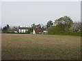
3
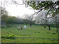
Four friends
This small paddock lies in the south west corner of the square.
Image: © Penny Mayes
Taken: 19 Apr 2005
0.17 miles
5
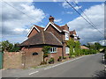
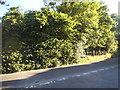
The Foxhunters on Kingsdown Road
This was clearly once a pub and records show that as such it dates from 1858. I cannot find though when it ceased to be a pub.
Image: © Marathon
Taken: 21 Jun 2019
0.21 miles