IMAGES TAKEN NEAR TO
Sharsted Road, SITTINGBOURNE, ME9 0HG
Introduction
This page details the photographs taken nearby to Sharsted Road, ME9 0HG by members of the Geograph project.
The Geograph project started in 2005 with the aim of publishing, organising and preserving representative images for every square kilometre of Great Britain, Ireland and the Isle of Man.

There are currently over 7.5m images from over14,400 individuals and you can help contribute to the project by visiting https://www.geograph.org.uk
Image Map
Images are licensed for reuse under creativecommons.org/licenses/by-sa/2.0
Notes
- Clicking on the map will re-center to the selected point.
- The higher the marker number, the further away the image location is from the centre of the postcode.
Image Listing (10 Images Found)
Images are licensed for reuse under creativecommons.org/licenses/by-sa/2.0
Image
Details
Distance
4
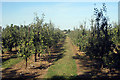
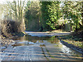
Apple Orchard
Off Homestall Road.
Image: © Oast House Archive
Taken: 19 Aug 2009
0.08 miles
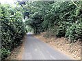
6
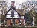
Sharsted Lodge
On Tickham Lane. Was once part of the Sharsted Estate but M2 Motorway cut through the estate leaving this lodge on the north side, alone.
Image: © David Anstiss
Taken: 24 Mar 2009
0.18 miles
7
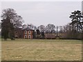
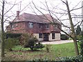
Lynsted Park
Large house on access road, of Tickham Lane, near Newnham.
Image: © David Anstiss
Taken: 24 Mar 2009
0.21 miles
8
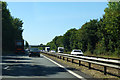
M2 westbound
Approaching an access bridge to Little Sharsted Farm.
Image: © Robin Webster
Taken: 2 Aug 2018
0.22 miles
9
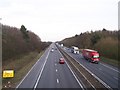
M2 Motorway to Faversham
As seen from bridge from Tickham Lane to Little Sharsted farm.
Motorway leads to Faversham from Sittingbourne/London.
Image: © David Anstiss
Taken: 24 Mar 2009
0.23 miles
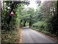
10
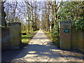
Entrance to Lynsted Park
Viewed from Tickham Lane.
Image: © pam fray
Taken: 6 Apr 2013
0.24 miles