IMAGES TAKEN NEAR TO
Nouds Lane, SITTINGBOURNE, ME9 0ES
Introduction
This page details the photographs taken nearby to Nouds Lane, ME9 0ES by members of the Geograph project.
The Geograph project started in 2005 with the aim of publishing, organising and preserving representative images for every square kilometre of Great Britain, Ireland and the Isle of Man.

There are currently over 7.5m images from over14,400 individuals and you can help contribute to the project by visiting https://www.geograph.org.uk
Image Map
Images are licensed for reuse under creativecommons.org/licenses/by-sa/2.0
Notes
- Clicking on the map will re-center to the selected point.
- The higher the marker number, the further away the image location is from the centre of the postcode.
Image Listing (8 Images Found)
Images are licensed for reuse under creativecommons.org/licenses/by-sa/2.0
Image
Details
Distance
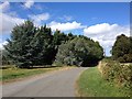
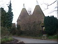
2
Nouds Farm
From the junction of Nouds Road and Bogle Road.
Image: © Penny Mayes
Taken: 12 May 2006
0.11 miles
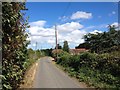
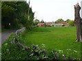
7
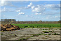
View north from Bogle Road
Across the field a windbreak hedgerow protects an orchard. The high ground of the Isle of Sheppey is on the horizon.
Image: © Robin Webster
Taken: 21 Mar 2017
0.22 miles
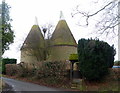
8
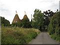
Nouds Oast, Nouds Road, Lynsted, Kent
Image: © Oast House Archive
Taken: 16 Aug 2008
0.23 miles