IMAGES TAKEN NEAR TO
Primrose Place, The Street, SITTINGBOURNE, ME9 0DA
Introduction
This page details the photographs taken nearby to Primrose Place, The Street, ME9 0DA by members of the Geograph project.
The Geograph project started in 2005 with the aim of publishing, organising and preserving representative images for every square kilometre of Great Britain, Ireland and the Isle of Man.

There are currently over 7.5m images from over14,400 individuals and you can help contribute to the project by visiting https://www.geograph.org.uk
Image Map
Images are licensed for reuse under creativecommons.org/licenses/by-sa/2.0
Notes
- Clicking on the map will re-center to the selected point.
- The higher the marker number, the further away the image location is from the centre of the postcode.
Image Listing (18 Images Found)
Images are licensed for reuse under creativecommons.org/licenses/by-sa/2.0
Image
Details
Distance
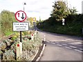
3
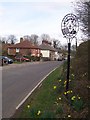
Doddington Village Sign
On The Street, as it goes into Village.
Image: © David Anstiss
Taken: 24 Mar 2009
0.04 miles
5
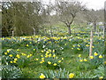
An amazing display of daffodils by The Street on the west side of Doddington
Image: © pam fray
Taken: 24 Mar 2008
0.06 miles


10
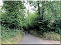
Lady Margaret Manor Road, near Doddington
Image: © Chris Whippet
Taken: 9 Sep 2016
0.19 miles