IMAGES TAKEN NEAR TO
Doddington, SITTINGBOURNE, ME9 0AY
Introduction
This page details the photographs taken nearby to ME9 0AY by members of the Geograph project.
The Geograph project started in 2005 with the aim of publishing, organising and preserving representative images for every square kilometre of Great Britain, Ireland and the Isle of Man.

There are currently over 7.5m images from over14,400 individuals and you can help contribute to the project by visiting https://www.geograph.org.uk
Image Map
Images are licensed for reuse under creativecommons.org/licenses/by-sa/2.0
Notes
- Clicking on the map will re-center to the selected point.
- The higher the marker number, the further away the image location is from the centre of the postcode.
Image Listing (9 Images Found)
Images are licensed for reuse under creativecommons.org/licenses/by-sa/2.0
Image
Details
Distance
1
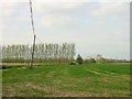
Redundant windbreak near Lynsted
The line of poplars was planted as a windbreak for an orchard (or possibly a hop garden) but the fruit trees have all gone at this place just south of the M2.
Image: © Penny Mayes
Taken: 19 Apr 2005
0.06 miles
2
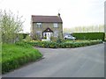
Road junction at Bistock
Just south of the M2.
Image: © Penny Mayes
Taken: 19 Apr 2005
0.06 miles


9
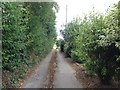
Chequers Hill Road
Heading to Doddington.
Image: © Oast House Archive
Taken: 19 Aug 2011
0.22 miles