IMAGES TAKEN NEAR TO
Blue Town, SITTINGBOURNE, ME9 0AL
Introduction
This page details the photographs taken nearby to Blue Town, ME9 0AL by members of the Geograph project.
The Geograph project started in 2005 with the aim of publishing, organising and preserving representative images for every square kilometre of Great Britain, Ireland and the Isle of Man.

There are currently over 7.5m images from over14,400 individuals and you can help contribute to the project by visiting https://www.geograph.org.uk
Image Map
Images are licensed for reuse under creativecommons.org/licenses/by-sa/2.0
Notes
- Clicking on the map will re-center to the selected point.
- The higher the marker number, the further away the image location is from the centre of the postcode.
Image Listing (8 Images Found)
Images are licensed for reuse under creativecommons.org/licenses/by-sa/2.0
Image
Details
Distance
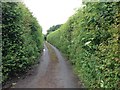
4
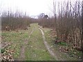
Track into Kingsdown Wood
This is on Down Court Road.
Image: © David Anstiss
Taken: 24 Mar 2009
0.16 miles
5
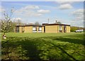
Bungalow in Mintching Wood
Not the prettiest house in the area, it is hidden from view much of the time but every twelve years the area of woodland around it is coppiced and it is revealed.
Image: © Penny Mayes
Taken: 18 Apr 2005
0.18 miles
6
Unnamed lane leading to Holly Bushes, near Milstead
Image: © Chris Whippet
Taken: 30 Jun 2016
0.21 miles
7
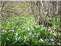
Mintching Wood
Wood anemones, bluebells and celandine in Mintching Wood. Mintching Wood covers about 1 square kilometre and consists of sweet chestnut coppice used for fencing. Not to be confused with the conker tree or horse chestnut, Aesculus hippocastanum.
Image: © Penny Mayes
Taken: 17 Apr 2005
0.21 miles
8
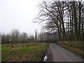
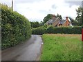
The start of Manor Road, en route for Milstead
Image: © pam fray
Taken: 24 Mar 2008
0.24 miles