IMAGES TAKEN NEAR TO
Cheney Hill, SITTINGBOURNE, ME9 0AH
Introduction
This page details the photographs taken nearby to Cheney Hill, ME9 0AH by members of the Geograph project.
The Geograph project started in 2005 with the aim of publishing, organising and preserving representative images for every square kilometre of Great Britain, Ireland and the Isle of Man.

There are currently over 7.5m images from over14,400 individuals and you can help contribute to the project by visiting https://www.geograph.org.uk
Image Map
Images are licensed for reuse under creativecommons.org/licenses/by-sa/2.0
Notes
- Clicking on the map will re-center to the selected point.
- The higher the marker number, the further away the image location is from the centre of the postcode.
Image Listing (7 Images Found)
Images are licensed for reuse under creativecommons.org/licenses/by-sa/2.0
Image
Details
Distance
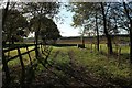
2
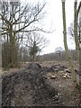
Woodland being cleared near Rodmersham Cricket Club
Image: © pam fray
Taken: 21 Feb 2008
0.15 miles
3
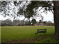
Rodmersham Cricket Club
The ground and the pavilion are waiting for the season to begin.
Image: © pam fray
Taken: 21 Feb 2008
0.18 miles
4
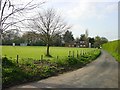
Rodmersham Cricket Club
From Bottles Lane.
Image: © Penny Mayes
Taken: 19 Apr 2005
0.19 miles
5
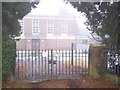
Highsted Pumping Station
On Bottom Pond Road
Image: © David Anstiss
Taken: 6 Jan 2009
0.23 miles
6
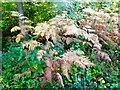
Bracken, Cromer's Wood, near Sittingbourne
Cromer's Wood is a 28 hectare ancient semi-natural woodland that sits on the southeast side of a dry slope valley. It was donated by Shell Research Ltd. to Kent Trust for Nature Conservation, now known as Kent Wildlife Trust, in 1996.
Image: © pam fray
Taken: 18 Oct 2022
0.24 miles
7
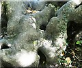
Beech tree, Cromer's Wood near Sittingbourne
Strangely shaped base of a tree on the east side of the wood. Cromer's Wood is a 28 hectare ancient semi-natural woodland that sits on the southeast side of a dry slope valley. It was donated by Shell Research Ltd. to Kent Trust for Nature Conservation, now known as Kent Wildlife Trust, in 1996.
Image: © pam fray
Taken: 18 Oct 2022
0.25 miles