IMAGES TAKEN NEAR TO
Highsted Valley, SITTINGBOURNE, ME9 0AD
Introduction
This page details the photographs taken nearby to Highsted Valley, ME9 0AD by members of the Geograph project.
The Geograph project started in 2005 with the aim of publishing, organising and preserving representative images for every square kilometre of Great Britain, Ireland and the Isle of Man.

There are currently over 7.5m images from over14,400 individuals and you can help contribute to the project by visiting https://www.geograph.org.uk
Image Map
Images are licensed for reuse under creativecommons.org/licenses/by-sa/2.0
Notes
- Clicking on the map will re-center to the selected point.
- The higher the marker number, the further away the image location is from the centre of the postcode.
Image Listing (11 Images Found)
Images are licensed for reuse under creativecommons.org/licenses/by-sa/2.0
Image
Details
Distance
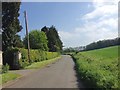
4
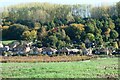
View from Cromer's Wood, near Sittingbourne
Looking across farmland to houses and bungalows in Highsted Valley.
Image: © pam fray
Taken: 18 Oct 2022
0.06 miles
6
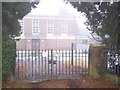
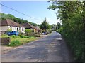
Highsted Pumping Station
On Bottom Pond Road
Image: © David Anstiss
Taken: 6 Jan 2009
0.11 miles
9
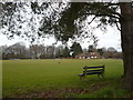
Rodmersham Cricket Club
The ground and the pavilion are waiting for the season to begin.
Image: © pam fray
Taken: 21 Feb 2008
0.24 miles
10
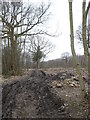
Woodland being cleared near Rodmersham Cricket Club
Image: © pam fray
Taken: 21 Feb 2008
0.24 miles