IMAGES TAKEN NEAR TO
South Bush Lane, GILLINGHAM, ME8 8PS
Introduction
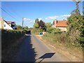
This page details the photographs taken nearby to South Bush Lane, ME8 8PS by members of the Geograph project.
The Geograph project started in 2005 with the aim of publishing, organising and preserving representative images for every square kilometre of Great Britain, Ireland and the Isle of Man.

There are currently over 7.5m images from over14,400 individuals and you can help contribute to the project by visiting https://www.geograph.org.uk
Image Map
Images are licensed for reuse under creativecommons.org/licenses/by-sa/2.0
Notes
- Clicking on the map will re-center to the selected point.
- The higher the marker number, the further away the image location is from the centre of the postcode.
Image Listing (3 Images Found)
Images are licensed for reuse under creativecommons.org/licenses/by-sa/2.0
Image
Details
Distance
2
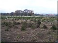
Field of Christmas Trees
On footpath from Spade Lane to South Bush Lane.
A2 Moor Street buildings in background.
Trees are very small, may need up to 10 years before ready for use.
Image: © David Anstiss
Taken: 27 Nov 2008
0.14 miles
3
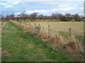
Footpath junction in Orchard
Path from South Bush Lane meets path from Moor Street (A2) to Meresborough. Path other side of fence heads to Meresborough Road, Moor Street.
Image: © David Anstiss
Taken: 27 Nov 2008
0.16 miles